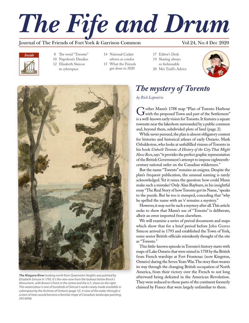
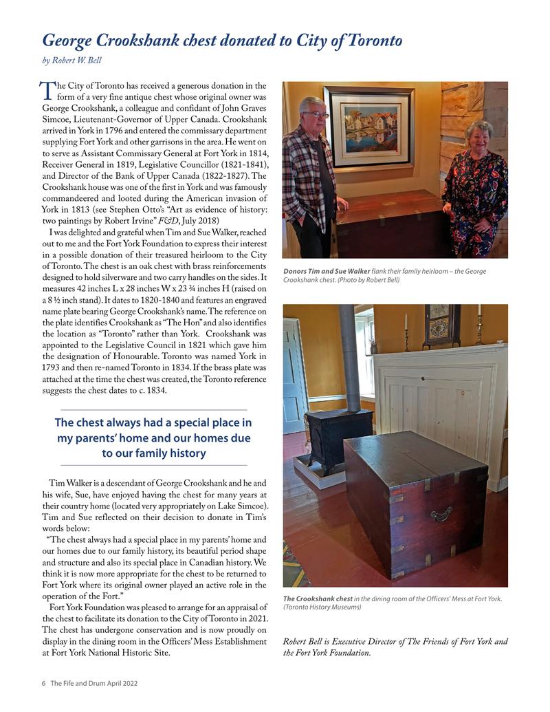
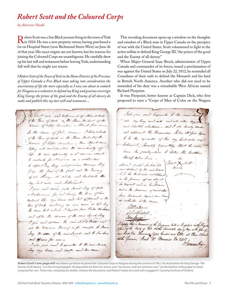
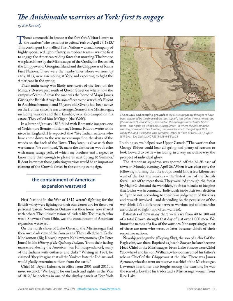
← The Fife and Drum / December 2020 (Vol 24, No 4)
↗ View this article in the original PDF newsletter
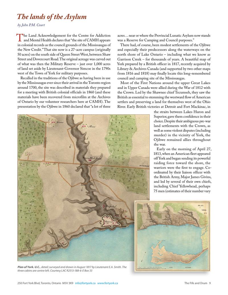
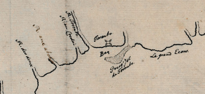
Gother Mann’s 1788 map “Plan of Torento Harbour with the proposed Town and part of the Settlement” is a well-known early vision for Toronto. It features a square townsite near the lakeshore surrounded by a public common and, beyond them, subdivided plots of land (page 2). While never pursued, the plan is almost obligatory content for histories and historical atlases of early Ontario. Mark Osbaldeston, who looks at unfulfilled visions of Toronto in his book Unbuilt Toronto: A History of the City That Might Have Been, says “it provides the perfect graphic representation of the British Government’s attempt to impose eighteenth-century rational order on the Canadian wilderness.”
But the name “Torento” remains an enigma. Despite the plan’s frequent publication, the unusual naming is rarely acknowledged. Yet it raises the question: how could Mann make such a mistake? Only Alan Rayburn, in his insightful essay “The Real Story of how Toronto got its Name,” speaks to the puzzle. But he too is stumped, conceding that “why he spelled the name with an ‘e’ remains a mystery.”
However, it may not be such a mystery after all. This article seeks to show that Mann’s use of “Torento” is deliberate, albeit an error imported from elsewhere.
We will examine a series of period documents and maps which show that for a brief period before John Graves Simcoe arrived in 1793 and established the Town of York, some senior British officials mistakenly thought of the site as “Torento.”
This little-known episode in Toronto’s history starts with maps of Lake Ontario that were seized in 1758 by the British from French warships at Fort Frontenac (now Kingston, Ontario) during the Seven Years War. The story then weaves its way through the changing British occupation of North America, from their victory over the French to not long afterward being defeated in the American Revolution. They were reduced to those parts of the continent formerly claimed by France that were largely unfamiliar to them.
The Laforce Map of Lake Ontario
Thirty years before Mann drew his plan, the British acquired two French manuscript maps of Lake Ontario. Neither of them uses the name Torento.
In August 1758, when the British attacked Fort Frontenac, two French naval vessels sought to sail out of the Cataraqui River into open water. Hampered by unfavourable winds, they were fired upon and hulled by British cannon. Both ships ran aground below the fort and were abandoned by captains and crews, who disappeared into the nearby woods. Fort Frontenac, its stores and the entire French fleet on Lake Ontario fell into British hands. One and possibly both maps were seized that day from the besieged French vessels.
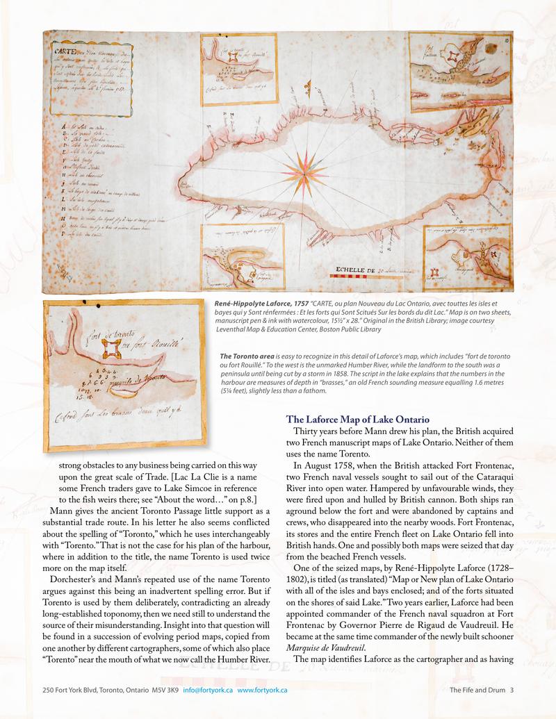
One of the seized maps, by René-Hippolyte Laforce (1728–1802), is titled (as translated) “Map or New plan of Lake Ontario with all of the isles and bays enclosed; and of the forts situated on the shores of said Lake.” Two years earlier, Laforce had been appointed commander of the French naval squadron at Fort Frontenac by Governor Pierre de Rigaud de Vaudreuil. He became at the same time commander of the newly built schooner Marquise de Vaudreuil.
The map identifies Laforce as the cartographer and as having
strong obstacles to any business being carried on this way upon the great scale of Trade.
Mann gives the ancient Toronto Passage little support as a substantial trade route. In his letter he also seems conflicted about the spelling of “Toronto,” which he uses interchangeably with “Torento.” That is not the case for his plan of the harbour, where in addition to the title, the name Torento is used twice more on the map itself.
Dorchester’s and Mann’s repeated use of the name Torento argues against this being an inadvertent spelling error. But if Torento is used by them deliberately, contradicting an already long-established toponomy, then we need still to understand the source of their misunderstanding. Insight into that question will be found in a succession of evolving period maps, copied from one another by different cartographers, some of which also place “Torento” near the mouth of what we now call the Humber River.
The Labroquerie Map of Lake Ontario
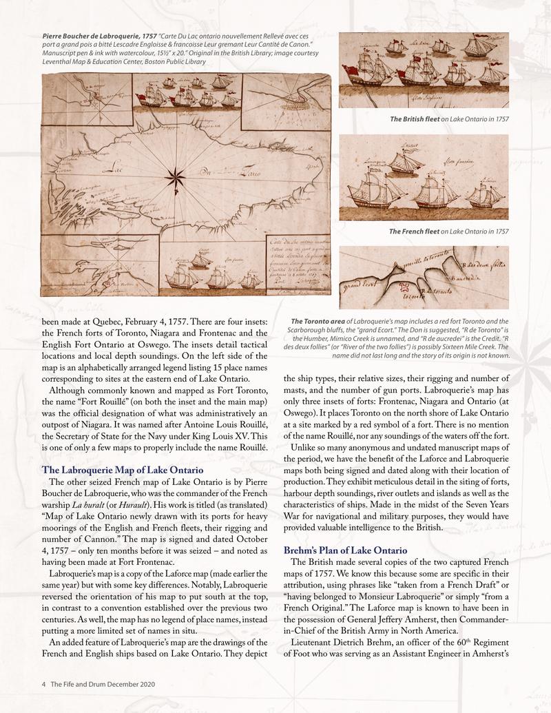
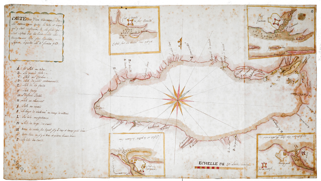
The other seized French map of Lake Ontario is by Pierre Boucher de Labroquerie, who was the commander of the French warship La huralt (or Hurault). His work is titled (as translated) “Map of Lake Ontario newly drawn with its ports for heavy moorings of the English and French fleets, their rigging and number of Cannon.” The map is signed and dated October 4, 1757 – only ten months before it was seized – and noted as having been made at Fort Frontenac.
Labroquerie’s map is a copy of the Laforce map (made earlier the same year) but with some key differences. Notably, Labroquerie reversed the orientation of his map to put south at the top, in contrast to a convention established over the previous two centuries. As well, the map has no legend of place names, instead putting a more limited set of names in situ.
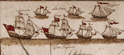
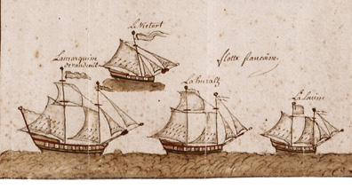
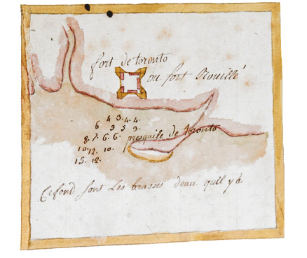
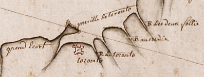
An added feature of Labroquerie’s map are the drawings of the French and English ships based on Lake Ontario. They depict the ship types, their relative sizes, their rigging and number of masts, and the number of gun ports. Labroquerie’s map has only three insets of forts: Frontenac, Niagara and Ontario (at Oswego). It places Toronto on the north shore of Lake Ontario at a site marked by a red symbol of a fort. There is no mention of the name Rouillé, nor any soundings of the waters off the fort.
Unlike so many anonymous and undated manuscript maps of the period, we have the benefit of the Laforce and Labroquerie maps both being signed and dated along with their location of production. They exhibit meticulous detail in the siting of forts, harbours, depth soundings, river outlets and islands as well as the characteristics of ships. Made in the midst of the Seven Years War for navigational and military purposes, they would have provided valuable intelligence to the British.
Brehm’s Plan of Lake Ontario
The British made several copies of the two captured French maps in 1757. We know this because some are specific in their attribution, using phrases like “taken from a French Draft” or “having belonged to Monsieur Labroquerie” or simply “from a French Original.” The Laforce map is known to have been in the possession of General Jeffery Amherst, then Commander-in-Chief of the British Army in North America.
Lieutenant Dietrich Brehm, an officer of the 60th Regiment of Foot who was serving as an Assistant Engineer in Amherst’s
army, made at least two copies of the French maps. Both were drawn in 1760, when Amherst was building Fort Crown Point on Lake Champlain in preparation for the final advance north to Montreal. Together with British armies advancing down the St. Lawrence from Oswego, and up the river from Quebec, this convergence on the unfortified city completed the conquest of New France. Brehm is known to have been at Crown Point until early in September 1760.
Just after the capitulation of Montreal on September 8, he was ordered to join the expedition to the west being assembled by Major Robert Rogers. The famous commander of the Rangers was being sent to assume control of the French posts in the interior, and Brehm’s assignment was to map and sketch their route. He travelled extensively in the lower Great Lakes and surrounding area and saw more of the territory in the two years he spent there than any other cartographer before him, French or English.

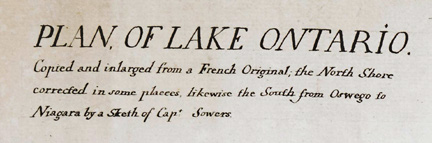
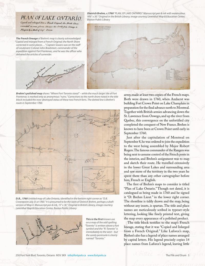
The first of Brehm’s maps to consider is titled “Plan of Lake Ontario.” Though not dated, it is catalogued as being made in 1760 and he signed it “D: Brehm Lieut.” in the lower right corner. The shoreline is tidily drawn and the map, being without any insets, is spartan. The title and place names are meticulously scribed in typeset-style lettering, looking like finely printed text, giving the map every appearance of a polished product.
The title block testifies to the map’s French lineage, stating that it was “Copied and Inlarged from a French Original.” Like Laforce’s map, Brehm’s also has a legend of place names arranged by capital letters. His legend precisely copies 14 place names from Laforce’s legend, leaving little
doubt that the original he copied is Laforce’s. And unlike Labroquerie’s map, Brehm’s is oriented with north at the top.
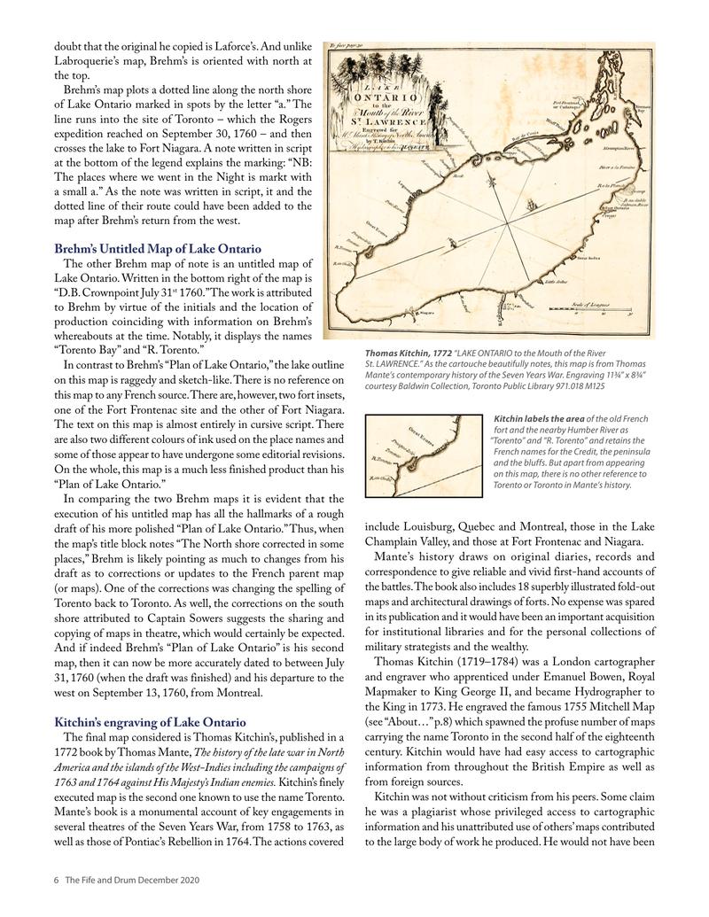
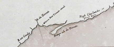
Brehm’s map plots a dotted line along the north shore of Lake Ontario marked in spots by the letter “a.” The line runs into the site of Toronto where the Rogers expedition reached on September 30, 1760 – and then crosses the lake to Fort Niagara. A note written in script at the bottom of the map explains the marking: “NB: The places where we went in the Night is markt with a small a.” As the note was written in script, it and the dotted line of their route could have been added to the map after Brehm’s return from the west.
Brehm’s Untitled Map of Lake Ontario
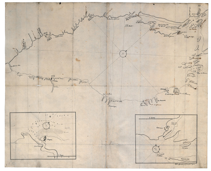
The other Brehm map of note is an untitled map of Lake Ontario. Written in the bottom right of the map is “D.B. Crownpoint July 31st 1760.” The work is attributed to Brehm by virtue of the initials and the location of production coinciding with information on Brehm’s whereabouts at the time. Notably, it displays 14 names “Torento Bay” and “R. Torento.”
In contrast to Brehm’s “Plan of Lake Ontario,” the lake outline on this map is raggedly and sketch-like. There is no reference on this map to any French source. There are, however, two fort insets, one of the Fort Frontenac site and the other of Fort Niagara. The text on this map is almost entirely in cursive script. There are also two different executions of ink: the place names and some of those appear to have undergone some editorial revisions. On the whole, this map is a much less finished product than his “Plan of Lake Ontario.”
In comparing the two Brehm maps it is evident that the execution of his untitled map has all the hallmarks of a rough draft of his more polished “Plan of Lake Ontario.” Thus, when the map’s title block notes “The North shore corrected in some places,” Brehm is likely pointing back to this earlier from his draft as to corrections or updates to the French parent map (or maps). One of the corrections on the south shore changes the spelling of Toronto back to Toronto. As well, the corrections on the south shore attributed to Captain Sowers suggests the sharing and copying of maps in theatre among officers, which would explain such a revision. And if indeed Brehm’s “Plan of Lake Ontario” is his second map, then it can now be firmly dated as between July 31, 1760 (when the draft was finished) and his departure to the west on September 13, 1760, from Montreal.
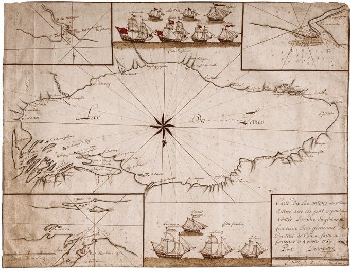
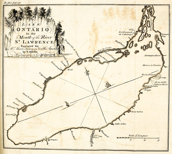
Kitchin’s engraving of Lake Ontario
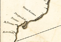
The first map to emerge from Brehm’s, published in a 1772 book by Thomas Mante, The history of the late war in North America and the islands of the West-Indies including the campaigns of 1763 and 1764 against His Majesty’s Indian enemies, Kitchin’s finely executed map is the second one known to use the name Torento. Mante’s book is a monumental account of key engagements in several theatres of the Seven Years War, from 1758 to 1763, as well as those of Pontiac’s Rebellion in 1764. The actions covered
include Louisburg, Quebec and Montreal, those in the Lake Champlain Valley, and those at Fort Frontenac and Niagara.
Mante’s history draws on original diaries, records and correspondence to give reliable and vivid first-hand accounts of the battles. The book also includes 18 superbly illustrated fold-out maps and architectural drawings of forts. No expense was spared in its publication and it would have been an important acquisition for institutional libraries and for the personal collections of military strategists and the wealthy.
Thomas Kitchin (1719–1784) was a London cartographer and engraver who apprenticed under Emanuel Bowen, Royal Mapmaker to King George II, and became Hydrographer to the King in 1773. He engraved the famous 1755 Mitchell Map (see “About…” p.8) which spawned the profuse number of maps carrying the name Toronto in the second half of the eighteenth century. Kitchin would have had easy access to cartographic information from throughout the British Empire as well as from foreign sources.
Kitchin was not without criticism from his peers. Some claim he was a plagiarist whose privileged access to cartographic information and his unattributed use of others’ maps contributed to the large body of work he produced. He would not have been
Sources & Further Reading
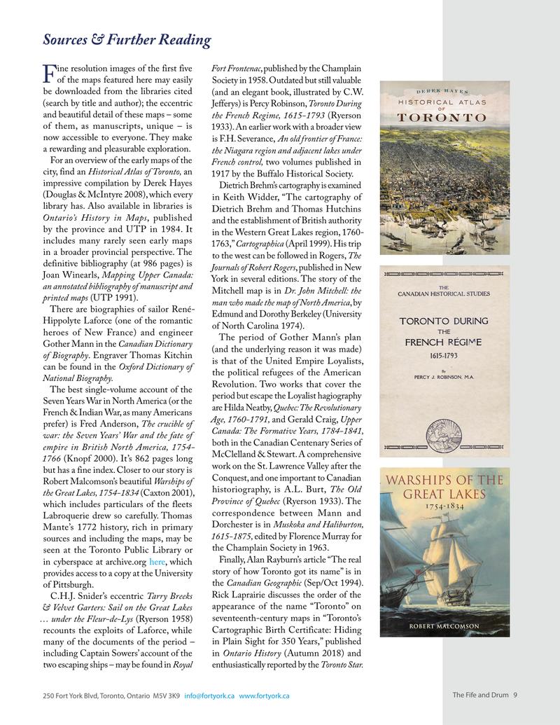
Fine resolution images of the first five of the maps featured here may easily be downloaded from the British Library (search by title and author); the eccentric and beautiful detail of each is worth it. All of them, as manuscripts, unique – is now accessible to everyone. They make a rewarding and pleasurable exploration.
For an overview of the early maps of the city, find an Historical Atlas of Toronto, an impressive compilation by Derek Hayes (Douglas & McIntyre 2008), which every library has. Also available in libraries is Ontario’s History in Maps, published by the province and by the department. It includes many rarely seen early maps in a broader provincial context. Included is a definitive bibliography (at 986 pages) is Joan Winearls, Mapping Upper Canada: an annotated bibliography of manuscript and printed maps (UTP 1991).
There are biographies of sailor René-Hippolyte Laforce (one of the romantic heroes of New France) and engineer Gother Mann in the Canadian Dictionary of Biography. Engraver Thomas Kitchin can be found in the Oxford Dictionary of National Biography.
The best single-volume account of the Seven Years War in North America (or the French & Indian War, as many Americans prefer) is Fred Anderson’s seminal Crucible of war: the Seven Years’ War and the fate of empire in British North America, 1754-1766 (Knopf 2000). It’s 862 pages long but has a fine index. Closer to our story is Robert Malcomson’s was published as Warships of the Great Lakes, 1754-1834 (Carton 2001), which includes particulars of the ships Labroquerie drew so carefully. Thomas Mante’s 1772 history, rich in primary sources and including the maps may be seen at the Toronto Public Library or in cyberspace at archivaria.com, which provides access to a copy at the University of Pittsburgh.
C.H.J. Snider’s eccentric Tarry Breaks & Velvet Garters: Sail on the Great Lakes … under the Fleur-de-Lys, 1679-1760 (1958) recounts the exploits of Laforce, while many of the documents of the period – including Captain Sowers’ account of the two escaping ships – may be found in Royal
Fort Frontenac, published by the Champlain Society in 1958. Outdated but still valuable (and an elegant book, illustrated by C.W. Jefferys) is Percy Robinson, Toronto During the French Regime, 1615-1793 (Ryerson 1933). His earlier work with a broader view is F.H. Severance, An old Frontier of France: the Niagara region and adjacent lakes under French control, two volumes published in 1917 by the Buffalo Historical Society. Dietrich Brehm’s cartography is examined in Keith Widder, “The cartography of Dietrich Brehm and Thomas Hutchins and the establishment of British authority in the upper Great Lakes region, 1760-1763,” Cartographica (April 1999). His trip to the west can be followed in Rogers, The Journals of Robert Rogers, published in New York in several editions. The story of the Mitchell Map war is in Dr. Mitchell’s Map: the man who made the map of North America, by Edmund and Dorothy Berkeley (University of North Carolina 1974).
The period of Gother Mann’s plan (and the underlying reason it was made) is that of the United Empire Loyalists, the political refugees of the American Revolution. Two works that cover the period but escape the Loyalist hagiography are F.H. Erskine, Quebec: The Revolutionary Age, 1760-1791, and Gerald Craig, Upper Canada: The Formative Years, 1784-1841, both in the Canadian Centenary Series of McClelland & Stewart. A comprehensive work on the St. Lawrence Valley after the Conquest, and one important to Canadian historiography, is A.L. Burt, The Old Province of Quebec (Ryerson 1933). The correspondence between Mann and Dorchester is in Muskoka and Haliburton, 1615-1875, edited by Florence Murray for the Champlain Society in 1963.
Finally, Alan Rayburn’s article “The real story of how Toronto got its name” is in the Canadian Geographic (Sep/Oct 1994). Rick Laprairie discusses the order of the appearance of the name “Toronto” on nineteenth-century maps in “Toronto’s Cartographic Birth Certificate: Hiding in Plain Sight for 350 Years,” published in Ontario History (Autumn 2018) and enthusiastically reported by the Toronto Star.
Original printed pages