← The Fife and Drum / Spring 2021 (Vol 25, No 1)
↗ View this article in the original PDF newsletter
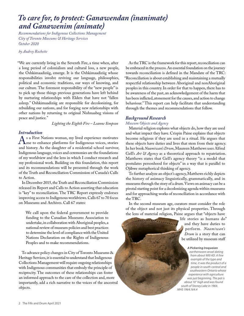
The Land Acknowledgement for the Centre for Addiction and Mental Health declares that “the site of CAMH appears in colonial records as the council grounds of the Mississaugas of the New Credit.” That site now is a 27-acre campus (originally 50 acres) on the south side of Queen Street West, between Shaw Street and Dovercourt Road. The original acreage was carved out of what was then the Military Reserve – just over 1,000 acres of land set aside by Lieutenant-Governor Simcoe in the 1790s west of the Town of York for military purposes.
Recalled in the traditions of the Ojibwe as having been in use by the Mississaugas ever since their arrival in the Toronto region around 1700, the site was described in materials they prepared for a meeting with British colonial officials in 1860 (and these materials have been recovered from microfilm at the Archives of Ontario by our volunteer researchers here at CAMH). The presentation by the Ojibwe in 1860 declared that “a lot of three acres… near or where the Provincial Lunatic Asylum now stands was a Reserve for Camping and Council purposes.”
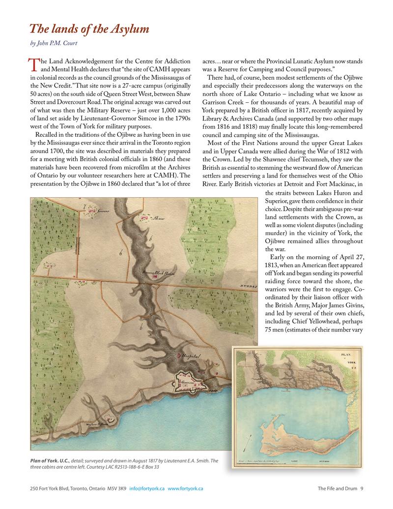
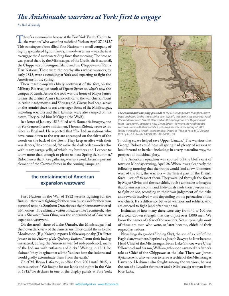
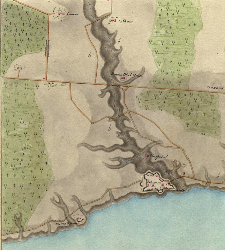
There had, of course, been modest settlements of the Ojibwe and especially their predecessors along the waterways on the north shore of Lake Ontario – including what we know as Garrison Creek – for thousands of years. A beautiful map of York prepared by a British officer in 1817, recently acquired by Library & Archives Canada (and supported by two other maps from 1816 and 1818) may finally locate this long-remembered council and camping site of the Mississaugas.
Most of the First Nations around the upper Great Lakes and in Upper Canada were allied during the War of 1812 with the Crown. Led by the Shawnee chief Tecumseh, they saw the British as essential to stemming the westward flow of American settlers and preserving a land for themselves west of the Ohio River. Early British victories at Detroit and Fort Mackinac, in the straits between Lakes Huron and Superior, gave them confidence in their choice. Despite their ambiguous pre-war land settlements with the Crown, as well as some violent disputes (including murder) in the vicinity of York, the Ojibwe remained allies throughout the war.
Early on the morning of April 27, 1813, when an American fleet appeared off York and began sending its powerful raiding force toward the shore, the warriors were the first to engage. Coordinated by their liaison officer with the British Army, Major James Givins, and led by several of their own chiefs, including Chief Yellowhead, perhaps 75 men (estimates of their number vary widely) spread out along the shoreline. A mixture of Ojibwe, Chippawa and Mississauga warriors, they had the bad luck to face the best unit of the invading force and were soon badly outnumbered. They fell back through the woods and at least five were killed. The day ended badly for everyone fighting on the side of the Crown.
The warriors were the first to engage
While the barracks of the garrison were only a few kilometres east of the landing site – where the Fort York branch of the Toronto Public Library is now – the warriors clearly were also not far away, camped somewhere on the Military Reserve. A beautifully drawn map now in the national archives (and supported by the other two maps) suggests where that camp may have been.
Surveyed and drawn by Lieutenant E.A. Smith of the British Army in August 1817, that map is part of a trove of maps, architectural drawings and engravings once owned by Sir John Sherbrooke, a career soldier who had been Lieutenant-Governor of Nova Scotia during the War of 1812. The collection was bought by LAC at auction in 2013, having been in Sherbrooke’s family since his death in England in 1830.
This map shows the Town of York shortly after the war, with the newly rebuilt fortifications of the garrison – the present Fort York – on the west side of Garrison Creek. About 150 buildings are shown, with a dozen of the government buildings and homes of prominent citizens labelled. Among these is the home of James Givins, at the top of what is now Givins Street, a few blocks from Trinity-Bellwoods Park. The ravine of Garrison Creek dominates the landscape and what is labelled “Dundas” is the present Queen Street. Three modest buildings can be seen on the south side of Queen, at the foot of the road to the Givins home. On open ground of the Military Reserve, they are unlabelled and would have been unremarkable as outbuildings of the garrison. No army records have been found for the construction here of three structures for the Mississaugas. However, an interesting precedent exists.
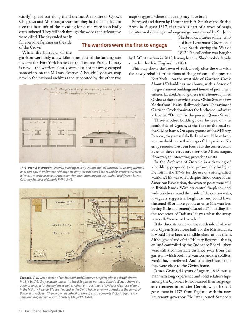
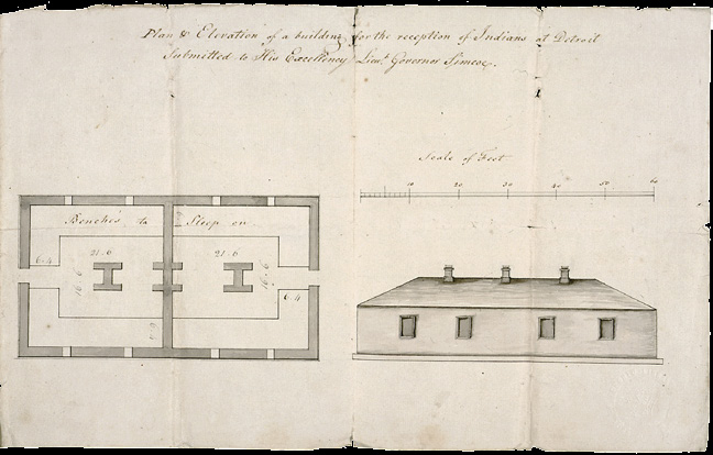
In the Archives of Ontario is a drawing of a building proposed (and presumably built) at Detroit in the 1790s for the use of visiting allied warriors. This was when, despite the outcome of the American Revolution, the western posts were still in British hands. With six central fireplaces, and wide benches around the inside of the exterior walls, it vaguely suggests a longhouse and could have sheltered 40 or more people at once (the warriors having little equipment). Labelled “a building for the reception of Indians,” it was what the army now calls “transient barracks.”
If the three structures on the south side of what is now Queen Street were built for the Mississaugas, it would have been a sensible place to put them. Although on land of the Military Reserve – that is, on land controlled by the Ordnance Board – they were still a comfortable distance away from the garrison, which both the warriors and the soldiers would have preferred. And it is significant that they were close to the Givins home.
James Givins, 53 years of age in 1812, was a man with long experience and solid relationships among the Ojibwe. He had learned their language as a teenager in frontier Detroit, when he had gone there in 1775 from England with the new lieutenant governor. He later joined Simcoe’s regiment of Queen’s Rangers and served as an interpreter and liaison officer. In 1797 he was made Assistant Superintendent of Indian Affairs for the Home District around York, responsible for the distribution of annual gifts (or tribute, as some regarded it) and diplomacy with First Nations in general.
He bought his substantial lot in 1802, not far from his fellow Queen’s Ranger veteran Aeneas Shaw and right across the road from the Military Reserve. By 1812, he and his wife Angelique had seven children and their home – designed by William Berczy and named Pine Grove – was one of York’s more substantial houses.
When war broke out, his job was to make sure that First Nations got the rations and ammunition they needed and, in battle, to coordinate their action with that of other British forces. He was with Brock at Detroit, fought alongside the warriors in the Niagara Peninsula and, as we’ve seen, at York. There is every indication that he and the Ojibwe leaders regarded one another with respect.
John Ross Robertson observed (years later) that few Mississaugas lived in muddy York before the war, preferring only to visit, for trade or otherwise, or to stop at the Givins home (which Robertson called a farm). On the morning of the battle, half a dozen of the wounded warriors took refuge there; Angelique famously cleared the front room of their solid house to dress their wounds (while Major Givins, on the staff of Major-General Sheaffe, was obliged to retreat eastward with the British column). That afternoon, her life was threatened and their home thoroughly ransacked by renegade American soldiers, who were aware of her husband’s connection to the warriors.
More than 30 years later, under pressure of all kinds, the Mississaugas accepted an offer of the Six Nations of the Grand River to move from the mouth of the Credit to better farmland
incompatible understandings of land use and ownership
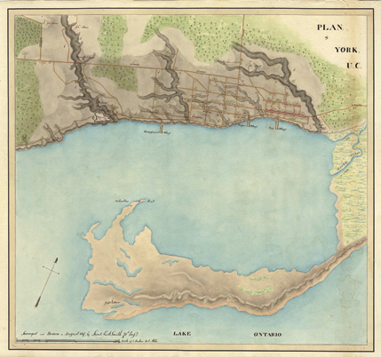
within the Six Nations tract (and it remains the home of the Mississaugas of The Credit First Nation today, at Hagersville). A map of the Military Reserve drawn in 1827 shows no trace of the three cabins. And by 1846, the land where they had stood – now severed from the Reserve – had become a construction site for the new Provincial Lunatic Asylum.
Ojibwe First Nations of southern Ontario held a council at Sarnia in September 1860. They agreed that their persisting land claims should be the main item on the agenda of their forthcoming meeting with the Duke of Newcastle, who was then Colonial Secretary and a member of the retinue of the visiting Prince of Wales. Among nine properties they considered non-surrendered and uncompensated was the parcel of about three acres that was “a Reserve for Camping and Council purposes.” That it had been on the Military Reserve was only one of many complicating factors, which included the inefficiency and poor record-keeping of the pertinent government departments.
Their meeting with the Duke of Newcastle happened on the day the Prince of Wales was welcomed to Queen’s Park. Only three Ojibwe elders were allowed to attend. The Duke met separately with his British and Canadian advisors, who reminded him that recent legislation changes in the United Kingdom – the passage of An Act Respecting the Management of the Indian Lands and Property in June – had handed all matters of land claims to Canadian authorities. Newcastle accepted that advice, agreeing that there was nothing he could do for the Ojibwe and that he should not interfere.
It was not until 1997 that a settlement was reached for the 200 acres around the current mouth of the Credit River in 1820 as a permanent home for the Mississaugas; it had been sold long before but never formally surrendered. By then it was prime real estate, and the Mississaugas in Hagersville accepted a settlement of $12.8 million for the land. Finally, to deal with the injustice of the 1805 purchase for ten shillings of what is now much of Toronto – a “purchase” that exploited two incompatible understandings of land use and ownership – the federal government offered a settlement of $145 million, which also encompassed a block of land in Burlington. Subsumed in the settlement was the question of the council and camping ground on the old Military Reserve. The offer, structured as modest individual payments and a substantial trust fund, was accepted in late 2010.
The three unlabelled cabins on Queen Street recorded on the 1817 map are an example of what Haitian scholar Michel-Rolph Trouillot has called “retrospective significance” – an event or a feature that was considered marginal at the time but, for us, is of great interest to us now. Yet because the events, people or buildings that were considered unimportant in their day are less likely to have left behind an archival record, many simply fade from history. The current imperatives of Reconciliation are driving reassessments of this past, not least throughout Canada’s archival profession, and at CAMH. The most apt metaphor may be in the title of the latest book by Donald Smith, a leading scholar of First Nations and of the Mississaugas in particular: those council grounds on the Military Reserve, we understand now, were “Seen but Not Seen.”
Sources & Further Reading
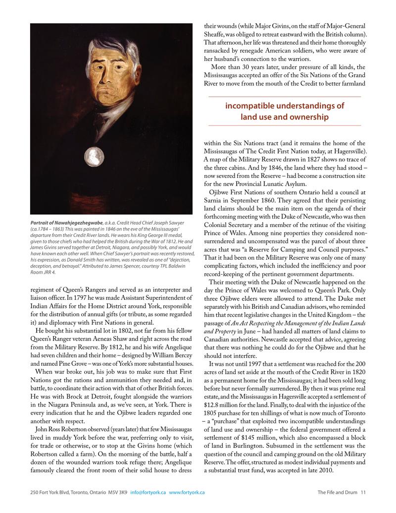
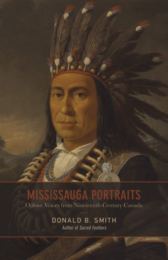
The revealing story of the painting of Chief Joseph Sawyer is told by Donald B. Smith in Mississauga Portraits: Ojibwe Voices from Nineteenth-Century Canada (UTP 2013), which is also a source of material here on the meeting of 1860. His latest book is Seen but Not Seen: Influential Canadians and the First Nations from the 1840s to Today (UTP 2020). It explores the history of Indigenous marginalization. For the concept of “retrospective significance,” see Michel-Rolph Trouillot, Silencing the Past: Power and the Production of History (Beacon Press 1995).
The claim presented by Ojibwe elders in 1860 is in the Archives of Ontario, MS-45, reel C-4-73 as “Mississauga Indian Land Claim … To the Right Honourable the Duke of Newcastle, Her Majesty’s Minister for the Colonies, etc.” A copy of this, including translations, is in the Archives of CAMH. Although out of date, a still useful account of the tortuous early land negotiations of the Mississaugas can be found in Peter Schmalz, The Ojibwa of Southern Ontario (UTP 1991). For the 2010 settlement, see the News Release “Canada and the Mississaugas of the New Credit First Nation Celebrate Historic Treaty Settlement, October 29, 2010, from what was then Indian and Northern Affairs Canada.
We are indebted to City of Toronto librarian Richard Gerard for drawing our attention to the Smith map and to Ryerson University professor Carl Benn for pointing to the structure in Detroit. There is another British Army map, dated March 16, 1816, which shows three cabins in the same place, but with less elaborate detail. For a broad selection of maps of York, early Toronto and especially the vicinity of the fort – including those relevant to this story – see the Maps link at www.fortyork.ca.
The definitive story of the Battle of York is Robert Malcomson’s Capital in Flames (Robin Brass Studio 2008); for other sources on the War of 1812, see page 8. Summaries of the lives of James Givins and Joseph Sawyer (Nawahjegezhegwabe) are in the Dictionary of Canadian Biography. For the story of the lawlessness following the battle – including a list of items lost by the Givins household – see “Silver, booze and pantaloons: the American looting of York in April 1813,” by Fred Blair in the F&D April 2020.
Original printed pages